|
If you think U.S. Census Bureau officials have their hands full
locating and counting everyone who lives in the United States, consider
the men and women at the National Oceanic and Atmospheric
Administration’s National Marine Fisheries Service (NMFS) who are
charged with counting fish in U.S. waters.
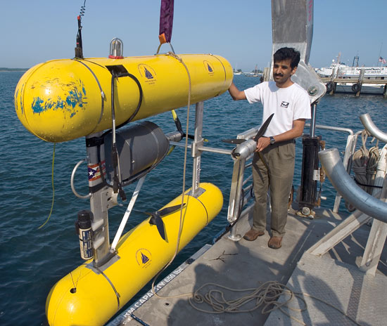
Hanu Singh stands by SeaBED, an undersea robot that swims about 8 feet
(2.5 meters) above the seafloor, flashing its strobe light and snapping
a photo every three seconds. It maintains a constant altitude and speed
of a ½ knot. (Photo by Tom Kleindinst, Woods Hole Oceanographic
Institution)
Their mission is to prevent the decline of fish stocks and the loss of
habitats that fish need to breed, spawn, feed, or grow. But a whole lot
of water gets in the way of their ability to locate those essential
habitats and to estimate fish stocks.
In recent years, scientists at Woods Hole Oceanographic Institution
have been lending a hand, applying new technologies and methods to see
into the sea and help assess and maintain fisheries.
How slow can you go?
For example, to survey seafloor populations of rockfish, NMFS
has relied on sampling with bottom trawls. The method has inherent
limitations.
“Rockfish live on rocks, and trawls get stuck on
rocks,” said Elizabeth Clarke, director of the NOAA Fishery Resource
Analysis and Monitoring Division in Seattle, Wash. “We have lots of
untrawlable areas, and our bottom trawl surveys cannot go into those
areas.”
Another option, sonar, doesn’t work well, because it
is hard to distinguish between sound signals reflected off rocks and
off fish buried amid rocks. So NMFS tested another alternative: SeaBED,
the underwater autonomous vehicle developed at Woods Hole Oceanographic
Institution (WHOI) by Associate Scientist Hanu Singh and colleagues in
the WHOI Applied Ocean Physics and Engineering Department.
SeaBED
flies about 8 feet (2.5 meters) above the seafloor, flashing its strobe
light and snapping a photo every three seconds. It maintains a constant
altitude and speed of a ½ knot.
“Most people ask us, ‘How fast do you go?’ Singh said. “We’re proud about how slow we can go.”
A treasure trove of seafloor images
In 2005, NMFS dispatched
SeaBED and Singh’s team to survey seafloor fish proposed for protection
off the coasts of Oregon and California. SeaBED collected 30,952
high-quality photos that WHOI scientists blended together into large
photomosiacs of rockfish habitats.
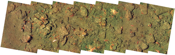
A photomosaic of clear images of a rocky seafloor gives scientists a
new way to assess rockfish populations and habitats. The images were
taken by the autonomous underwater vehicle SeaBED, developed in the lab
of Hanumant Singh of the WHOI Applied Ocean Physics and Engineering
Department. (SeaBED, Woods Hole Oceanographic Institution)
“The images were great,”
Clarke said. “The fish were easy to identify. We saw invertebrates
tucked in all around the rocks, as well as the fish. The photomosaics
give us a large perspective, so we can see the relationships between
geological features, fish, and invertebrates.”
To store, manage,
and analyze this overflowing treasure trove of images, Vicki Ferrini,
data manager of the National Deep Submergence Facility at WHOI, created
FISH_ROCK, a computer software tool that gives scientists the ability
to identify and count organisms in digital seafloor images. Using
FISH_ROCK, scientists can annotate each image with information about
the numbers and kinds of fish, invertebrates, and seafloor
characteristics (boulders, sand, pebbles, mud, etc.). The software also
marries SeaBED’s precise navigation data to each photo. So with a few
keystrokes, scientists can automatically search and sort the photo
database—to count the number of specific rockfish such as hake or
bocaccio in a given area, for example, or determine the particular
environment they prefer.
“We’ve never had anything like this tool before,” Clarke said. “It’s a lifesaver that is essential to getting our work done.”
Clarke
said SeaBED is cost-effective. It can cover a lot of territory,
photographing 3 to 6 miles (5 to 10 kilometers) on a typical six-hour
dive. It runs autonomously, so that a research vessel can
simultaneously conduct other research while SeaBED completes its
mission. And it is controlled by a laptop computer, so SeaBED can also
be used on less-expensive vessels, such as fishing boats.
--------------------------------
Credits to http://whoi.edu/oceanus/viewArticle.do?id=15246§ionid=1021 |
